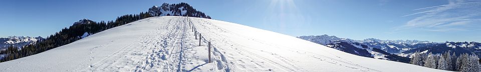
Date: 05-10-2013 12:19-12:57 UTC![]()
My first activation outside HB9. I decided to extend my business trip to Skopje (Macedonia) and head for a SOTA activation. Thankfully, two of my work colleagues, Andon and Frosina, agreed to act as local guides. Due to their biking activities they were very familiar with the mountains north of Skopje and suggested to head up Mount Ramno. There’s a paved road going up almost to the top, taking less than one hour driving from Skopje by car (passing the villages Pobozhje and Brodec). After a short warmup hike to another (non SOTA) summit nearby, we tackled Ramno which took about 30 minutes of easy walking.
On the summit there’s a large (probably military) base, so the highest point is not accessible. There’s however enough space to the east of the base that is still within the activation zone. I was worried a bit about getting into trouble when erecting the antenna, but fortunately we were completely ignored by the base’s staff.
There weren’t any good possibilities for mounting an antenna mast (I didn’t dare to use the base’s fence), so a guying kit would have helped. We had to improvise a bit using some rocks and the hiking sticks. Due to the not so optimal (low hanging) antenna setup, the QSOs came in slowly, but in the end I was very satisfied with the 16 QSOs from all over Europe. The last QSO was even a S2S from DM/SX-001 (Fichtelberg), being somehow the cherry on the top of the activation.
After the activation, we concluded the day with a nice picnic with some cheese, croissants, dried meat and an excellent local red wine in a nearby monastery. What great way to end a SOTA day. Many thanks to Andon and Frosina for their guidance and company!
Category Archives: Activations
HB/OW-009 Hochstollen – 2481m, 8 points
Date: 29-09-2013 12:17-13:09 UTC![]()
Joint activation with Paul HB9DST on a nice Saturday in late September. The road to Melchsee-Frutt is open on even hours only and costs a fee of CHF 36. It might therefore be preferable to use the free parking at Stöckalp and take the cable car to Melchsee Frutt (CHF 26.80 two way, CHF 13.40 with half-tax or GA card). There is good information available (also in English) on http://www.melchsee-frutt.ch.
From the top station at Melchsee-Frutt, the path to Hochstollen is well marked and takes about 2 hours (moderately steep). At Abgschütz (about 1h 40min from Melchsee-Frutt) the path splits and it’s not very clear which one to take (see picture below). Both actually lead to Hochstollen eventually, however the path to the right is the official one and more safe. On the summit, there’s plenty of space to set up antennas, also several fence posts that can be used as mast support; there’s also a big summit cross. The summit is quite popular and there were always a couple of other hikers present. If you took the cable car from Stöckalp, be advised that it is in service only until 17:20 (we almost missed it, thanks Paul for the reminder!), so you should leave the summit by 15:30 latest.
HB/UR-066 Scheidegg – 1407m, 2 points
Date: 7-09-2013 11:07-12:59 UTC![]()
The road up from Lake Lucerne up to Isenthal is breathtaking. It is carved into an almost vertical wall of rock and offers a stunning view down to the lake and the surrounding mountains. There is also a public bus stop very close to the cable way, so this summit can also easily be reached using public transport. There is also space for about 2-3 cars just next to the cable way. The valley station of the cable way is unmanned; you have to use the phone to ring up and state your wish to be lifted up. Then hop in, and off you go. Once on the top, nobody was at the summit station either, so after some time I decided to walk to the nearby farm house. And sure enough: the farmers dog announced me, and very soon his wife showed up to collect the fare (CHF 7.- two way).
From the farm, the summit is only about 30min on foot. The lower part was a bit wet an slippery, but this improved once the path entered the forest. Enjoy the view down to the lake at this point, as the rest of the way is in the forest and there’s not much to be seen.
At one place, the marking for the path was worn out and it was not clear how to proceed (see photos below, it’s the less obvious path straight on over the rocks). On the ridge, there was one or two spots where I felt a tiny bit uncomfortable (terrain dropping sharply just left and right of the path), but it was never technically difficult.
The summit was quiet and undisturbed, there was only one hiker’s couple during the two hours I stayed. As I had some time on my hand, I chased some S2S (got 11 in the end). I was lucky that day and achieved my first intercontinental S2S QSO (with W4ZV/P on W4C/EM-047 in North Carolina).
HB/NW-014 Niederbauen Chulm – 1923m, 6 points
Date: 31-08-2013 11:28-12:19 UTC![]()
There is a small cableway (8 persons per cabin) going up from Emmeten to Niderbauen Station. It’s rather expensive for the short ride (CHF 20.- return ticket), the ride is however quite spectacular and saves you 800m of ascent. The area is extremely popular with paragliders, so expect some waiting time at the cableway when there’s good flight wx. The walk from Niderbauen Station to Chulm (the summit) is not difficult, moderately steep and takes about 1 hour. The summit was quite crowded as it was a nice late-summer weekend, there is however plenty of space around the summit and a lot of fence poles to mount your antenna. There was an unexpected long pileup on 30m which lasted for almost 1 hour (58 QSOs in 50 min). In winter, the summit can also be accessed on snow shoes (I’ll be back…).
HB/SZ-035 Dossen / Dosse – 1685m, 4 points
Date: 03-08-2013 12:42-13:38 UTC![]()
This was the second activation on this day, after Rigi Kulm HB/SZ-021. The railway station ‘Rigi Kaltbad’ can either be reached by cogwheel railway from Viznau (shorter) or Goldau, or by cable car from Weggis. The latter is preferrable as it runs every 30min (railway only once every hour). From the railway station Kaltbad, the way remains almost flat until you reach the foot of the Dossen at Understette. From there it is a quite steep final ascent to the summit of about 230m (about 30min). On the way to Understette you can use the ‘Felsenweg’ (closed in winter), a path spectacularly carved into a vertical wall of rock with a great view to Lake Lucerne and its surrounding mountains. Once arriving at the summit cross, there’s a comfortable bench to put up your station. A highlight was the DX QSO with K4DY in North Carolina on 12m.
Continue reading
HB/SZ-021 Rigi Kulm – 1798m, 6 points
Date: 03-08-2013 10:03-10:45 UTC![]()
Rigi Kulm can be easily reached on Europe’s first cogwheel railway. You can either start at Viznau or Goldau. There’s a one-day ticket for CHF 66 (half-fare 33 CHF) that allows you to use all Rigi railways and cable cars during the day. This comes in handy if you want to activate also HB/SZ-035 Dossen on the same day (as I did). From the railway station on the top, its only a few minutes walk to the summit.
Continue reading
HB/SG-049 Selun – 2205m, 8 points
Date: 28-07-2013 11:00-11:42 UTC![]()
Activation together with my XYL Roya, Andy (a friend from QRL) and his family. There’s a quite spectacular cable car (CHF 18.- two way) going up from Starkenbach, saving the first 600m altitude. There’s limited parking available next to the cable car station. From the top station, the way is well marked, continuously ascending, but never very steep. It can be done in 1.5-2 hours. The only possible antenna support on the summit is the summit cross. As the summit is usually crowded (especially on weekends), I prepared a guying kit for the fiberglass mast the day before, so I could set up the antenna elsewhere. Thanks to Andy and his son, the antenna was set up quickly and was holding up fine, despite the quite strong and gusty Föhn wind.
Continue reading
HB/SZ-019 Grosser Mythen – 1898m, 6 points
Date: 25-07-2013 09:09-10:20 UTC![]()
The Grosse Mythen is a very popular mountain due to its interesting shape and beautiful 360 degree view from the top. On weekends it is very crowded, so avoid this time whenever possible. The fastest way to access the summit is by using the cable car from Brunni to Holzegg (car park available in Brunni, CHF 15.- for a two way ticket). From Holzegg it takes little more than 1 hour to the summit on foot. The way up has been widened and all difficult parts are secured by rails and chains. So it’s not difficult (albeit quite steep sometimes). On the top, a restaurant (!) offers some rewards for the exhausting ascent.
Continue reading
HB/NW-020 Salistock – 1896m, 6 points
Date: 14-07-2013 10:53-12:02 UTC![]()
Joint activation together with Paul HB9DST. Perfect day, sunny, but not too hot. Most of the ascent can be done using two small cable cars. The valley station is not manned, you have to use a telephone within the cabin to signal ahead that you’re ready for departure. There are plenty of parking spaces available, or if you prefer public transport (such as Paul), take a 15min walk from the railway station “Grafenort”. The fare for the cable car has to be payed at the middle station (CHF 12.- for a two-way ticket). Follow the sign posts to “Lutersee”. Once you reach “Hüethütte” on 1740m (after a bit more than 1h), keep left and head for the summit. There is no path up, so you have to find your own way across the meadow.
Continue reading
HB/SG-034 Stockberg – 1781m, 6 points
Date: 22-06-2013 12:21-13:23 UTC![]()
Not so promising WX when arriving, the Stockberg was hidden within a big cloud. A special permit is required to drive up to Risipass with a motor vehicle. This permit can be bought at a small (unmanned) booth on the way up. Be sure to bring CHF 10.- in cash, as there is no possibility for exchange. The way up from Risipass to Stockberg is rather easy and takes less than 1 hour. It gets a little steep once you reach the final ridge. There’s a new wooden cross on the summit (marked 2012). Visibility was down to about 50m, however later in the afternoon it cleared up a bit and it was possible to get some glimpses down in the valley and of the surrounding mountains.
Continue reading